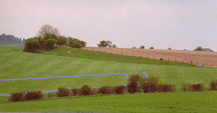 |
| Photograph of the location of the enclosure and barrow
(marked in blue) taken from Bokerley dyke towards a long barrow at the end of the Dorset cursus. |
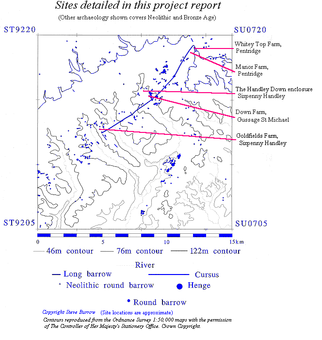
Whitey Top Farm, Pentridge (SU04181883)
The immediate vicinity of this site has been intensively studied over the past hundred years. Just c.250m to the northwest is the end of the Dorset cursus, the longest Neolithic earthwork in Britain. Whilst c.20m to the east is Grim's Ditch which probably has its origins in the Bronze Age (RCHM 1975), as well as the more impressive Romano-British Bokerley Dyke, which forms the Dorset / Hampshire border. In addition, to these the RCHM (Bowen 1990) note three long and three round barrows within a 200m radius of the enclosure.
|
| Photograph of the location of the enclosure and barrow
(marked in blue) taken from Bokerley dyke towards a long barrow at the end of the Dorset cursus. |
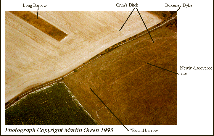
Given this concentration of known archaeology it was something of a surprise when a hitherto unrecognised site was identified within this complex by Martin Green. The aerial photograph of the site clearly shows a rectangular enclosure running roughly east - west. At the top of the photograph one of the long barrows at the end of the cursus can also be seen, whilst Bokerley Dyke enters the photograph on the right side.
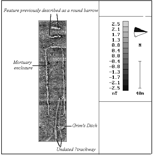
With the consent of the farmer, Mr White, a geophysical survey using an FM36 Fluxgate Gradiometer was carried out. In the absence of an auto-logger time factors meant that it was only possible to survey the site at 1 x 1m intervals, although considerable detail can still be seen in the resulting plot.
The geophysical survey clipped the edge of Grim's ditch, which shows up clearly, as does a trackway feature which appears to cut through the entrance of the rectangular enclosure. Before turning to the enclosure itself it is also worth noting that the results clearly show that the barrow at the western end of the survey area is not a round barrow, as recorded previously, but rather a long barrow. The site is certainly at the small end of the size range normal for long barrows, however, in form it closely resembles such barrows as Kingston Deverill and Woodford, both in Wiltshire, and Alfriston, East Sussex (see Kinnes 1992).
The rectangular enclosure can be identified with some confidence as being a Neolithic mortuary enclosure, although excavation will be necessary before this can be finally confirmed. The width of the trench surrounding the site is probably about 1.5m across, and is certainly too insubstantial to have formed a mound over the interior. It would therefore seem likely that the enclosure was bounded by a palisade, possibly similar to that present at sites such as Wor Barrow, Dorset (Pitt Rivers 1898), and Fussell's Lodge, Wiltshire (Ashbee 1966).
The identification of a diminutive long barrow, as well as a mortuary enclosure at the eastern end of the Dorset cursus indicates that more varied burial practises were current in the vicinity than are suggested by the major long barrows alone. Perhaps a programme of excavation within the enclosure would reveal the excarnation site which serviced the Neolithic barrows of the immediate area!
Bibliography
Ashbee, P. 1966 The Fussell's Lodge long barrow excavations, 1957. Archaeologia 100, 1-80.
Bowen, H.C. 1990 The archaeology of Bokerley Dyke. London: HMSO.
Kinnes, I. 1992 Non-megalithic long barrows and allied structures in the British Neolithic. London: British Museum Occasional Paper 52.
Pitt-Rivers, A.L.F. 1898 Excavations in Cranborne Chase, vol IV. Privately Printed.
Royal Commission on Historical Monuments (England) 1975 An inventory of historic monuments in the County of Dorset, vol V, East Dorset. London: HMSO.
![]() Return
to introduction
Return
to introduction
![]() Forward
to research at the Handley Down enclosure, Sixpenny Handley
Forward
to research at the Handley Down enclosure, Sixpenny Handley
This page is maintained by Steve Burrow, for further information contact sburrow@bournemouth.ac.uk