Summary of field work 2002-3
By John
Gale, Paul Cheetham,
Joanna Laver and Claire Randall
A
second season of field evaluation took place between 4th
August and
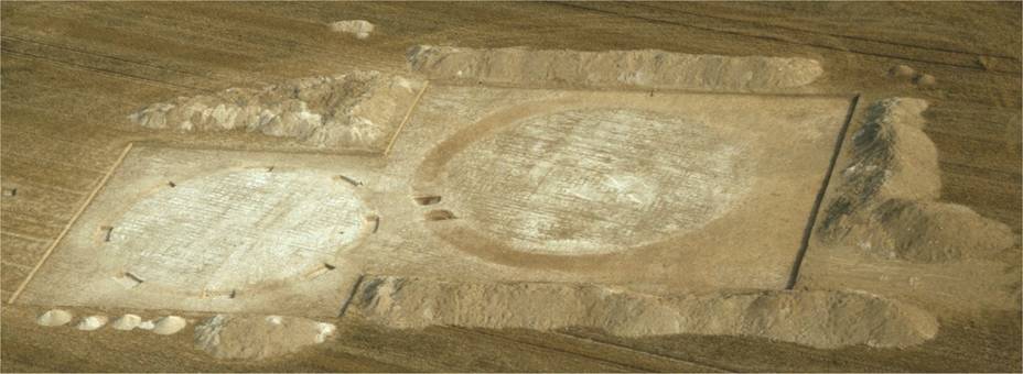
Fig 1
Area
excavation of Barrows 1 and 2 photographed from the air in September
2003. ©
John Gale
Introduction
As
part of the research design brief for the Knowlton Project (Gale 2002,
Gale
2003) concerning the evaluation and quantification of prehistoric
settlement
and associated activity within the Allen valley of East Dorset,
attention has
been partially focussed on the extensive barrow cemeteries that
dominate the
valley. Several concentrations of round
barrows (mostly surviving only as groups of ring ditches in an
archaeological
rich prehistoric landscape that has been devastated by intensive arable
farming), occur over a 5km stretch of the Allen Valley between the
Knowlton
complex to the north, and the High Lea farm Group to the south. Very little is known about any of these
funerary monuments beyond those general assumptions drawn by analogy
with
examples studied elsewhere in
The
clear foci for the funerary monuments within the
Whilst
the greater concentration of barrows within the Allen valley appear to
be
located around the Knowlton Henge complex
their
distribution would seem to extend from here to the south, mainly in
linear
groupings more or less following the line of the river Allen. The end of these concentrations would appear
to be found at the High Lea Farm Barrow group between the villages of Witchampton and Hinton Martell.
As
with the majority of barrows in the Allen valley the High Lea Farm
group is
extremely poorly preserved with only two of the group surviving as
upstanding
earthworks. However, both of the
surviving barrows owe their partial conservation to their location
within the
headlands of the field known as Kings Close where the plough is
frequently
lifted and turned and therefore consequently is subject to a lesser
degree of
damage. Elsewhere in the field the presence of numerous ring ditches
are
attested through crop marks visible on aerial photographs.
One such photograph (NMR 4437/04, SU 0006/8)
taken obliquely when the field contained a crop of pea in 1989,
illustrates a
dense concentration of ring ditches and other maculae which appears to
represent a definable cemetery group of ploughed out barrows,
consisting of at
least three distinct linear groupings.
Whilst
such evidence attests to the presence and location of an extensive
barrow group
it provides little effective information as to the sequential
chronology, or
nature of the barrow clustering. In
addition, whilst the barrows have had much (if not all) of their above
ground
features destroyed, the survival of below ground features (grave cuts,
earth
fast cremation urns etc.) remains undetermined. With these factors in
mind it
was decided to initiate a two step evaluation of the cemetery contained
within
Kings Close over two successive seasons commencing in 2002.
During
the examination of the aerial photographic evidence available at the
National
Monuments Record centre at
Kings Close evaluation - step 1 (August – September 2002)
During
a four-week period a programme of fieldwork was instigated to explore
the
location and survival of archaeological features associated with the
known
barrow group at High Lea Farm. The 15ha field known as Kings Close was
subjected to an extensive programme of Geophysical analysis using a
range of
techniques and equipment to both locate and explore the surviving
features of
the barrow group (see below). In the
wake of the geophysics programme a sample area of the field was defined
to
assess the extent of archaeological material within the current plough
soil and
to examine if the barrows were still being actively disturbed by the
arable
regime.
Test-pitting 2002
A
total of 67 (1m x 1m) test pits were hand excavated over an area of
25940 sq. m
located in the north of Kings Close. The
sampled area was chosen to maximise the range of features evidenced by
both the
geophysics results (see below) and those contained within the aerial
photograph
(NMR 4437/04, SU 0006/8) taken in 1989.
The test-pits were placed systematically within a grid and were
spaced
at 20m intervals.
After
marking out each test-pit was hand excavated and the plough soil was
removed
and screened through a 6mm-mesh sieve.
Soil layers and or features below the plough soil were not
excavated but
when present were contextualised and recorded.
With few exceptions the plough soil (defined here as the last
cultivation horizon resulting from the 2001 ploughing of the field),
lay on top
of a further soil layer largely differentiated from the uppermost soil
by a
larger quantity of chalk within its matrix.
In all likelihood this soil is probably an earlier plough soil,
the
result of an episode/s of deeper ploughing in recent times.
Material
recovered from the active plough soil throughout the test-pitting
exercise
consisted of minimal quantities of cultural material mostly comprising
of
relatively modern ceramic material (brick, tile and small quantities of
earthen-ware, which are probably of Verwood
types. With the exception of a singular
flint tool (an awl), material dateable to the late Neolithic or the
early-mid
Bronze Age consisted of a few struck flint flakes with no evidence of
prehistoric pottery having been recovered.
The
excavation of the test-pits failed to find any clear evidence that the
barrows
were being actively destroyed at the present time and certainly no
material was
recovered within the plough soil to indicate that funerary deposits
were being
actively destroyed.
Test trenching
2002
Alongside
the systematic sampling strategy employed to evaluate the surviving
archaeology
at the site, limited trial trenching was applied in targeted areas
where
specific features were identified as having survived evidenced by the
results
of the geophysical survey (fluxgate gradiometry). Two adjacent barrows were chosen for further
investigation and prior to excavation both barrows were subjected to
further
detailed geophysical investigation (see Geophysics below).
To confirm the presence of the ring-ditches
of both the chosen barrows and to tentatively explore the area bounded
by the
ring ditches two small excavation trenches were aligned to cross each
of the
barrows ditches. The trial trench located on the smaller of the two
barrows was
subsequently extending to its centre. At
this stage the intention was to confirm the presence of archaeological
deposits
only, with the option to excavate being part of a later phase of
investigation
(Step 2 below).
Trench 1
Trench
1 was positioned on the larger of the two barrows and was 1m wide and
8m
long. The modern plough soil was removed
from the trench by hand and was screened through a 6mm sieve. At the base of the plough soil only two
contexts were recorded, the natural bedrock and the fill of the barrows
ditch. The barrow ditch fill was
approximately 1.3m in width and was bounded on either side by weathered
chalk
bedrock in which the scoring marks of the plough could be clearly seen. Materials recovered from the plough soil were
small in number and consistent with those from the test-pits – there
was no evidence
of funerary deposits either in situ
or disturbed.
Trench 2
Trench
2 was positioned on the smaller of the two barrows and consisted of an
‘L’
shaped trench. The longer primary axis of the trench was 10m in length
crossing
the barrow from outside of the ring ditch ending at its approximate
centre
where a 3m extension was excavated perpendicular to the main axis. As
with
Trench 1 the plough soil was removed by hand and screened through a
6mm-mesh
sieve. Material recovered from the
plough soil was similarly consistent with previous examination of the
plough
soil elsewhere on the site, with no evidence for funerary deposits or
material. As with Trench 1 the presence
of a soil fill that bisected the excavation trench, is entirely
consistent with
the ditch predicted by the geophysics results. This ditch fill was
approximately 0.75m wide and was bounded internally and externally by
plough
damaged natural chalk.
Trench 3
In
addition to the trial trenching of a sample of the known barrow
population
within the group a third trial trench was instigated to examine the
anomalous
results provided by aerial photography and geophysical investigation in
the
north of Kings Close. Whilst aerial
photography determined the presence of a number of maculae in the north
of the
field which appear as crop marks consisting of ‘filled’ circles they
did not
similarly register on the magnetometer survey of the same area. Whilst it could not be discounted that these
features were possibly pond barrows (the aerial photograph identifies
at least
five similar anomalies) it seemed that they were much more likely to be
geomorphological in origin.
To further explore these features Trench 3 was located over one
of them.
The trench was 10m long by 1m wide.
As
with previous trenches all of the plough soil was removed by hand and
screened
through a 6mm-mesh sieve. Below the
plough soil a well-sorted humic soil was
encountered
over the whole of the trench, which was systematically removed by hand
and
screened. The depth of this deposit was
nowhere greater than 10cms and it appears to be an earlier agricultural
horizon
that had survived recent plough activity because of the greater soil
depth in
this part of the field. Below this layer a further continuous layer of
soil was
found which was remarkably chalk free. A sondage was
excavated
in the north-western corner of the trench to explore this soil and 0.6m
of it
was removed without encountering any change in the deposit. It would appear that the deposit is a colluvial soil fill, part of a much deeper
deposit that is
probably natural in origin and is almost certainly a doline/sinkhole,
not an uncommon feature in areas where the cretaceous chalk beds are
closely
associated with Tertiary sand and gravel deposits (for a discussion on
the
formation of Dolines in Dorset see House
1991). The colluvial
deposit contained, as one might expect, a chronological mix of cultural
materials with pottery being the most numerous material recovered. The fabrics noted consist of later earthen
wares (of Verwood types) and also
fragments of later
prehistoric material albeit in relatively small quantities. The trench was not excavated beyond a depth
of 1.2m below the modern ground surface.
Kings Close evaluation - step 2 (August – September 2003)
The
programme of archaeological investigation instigated in 2002 had
clearly
established the presence and location of surviving in-situ
archaeological deposits within the High Lea Barrow Group
but the extent of survival was as yet weakly defined.
Step 2 of the evaluation process, instigated
during the late summer of 2003, was targeted to investigate a sample of
those
known deposits via the area excavation of the two ring-ditches
(barrows) that
had been the subject of the trial trenching in the previous season
(fig.,1, 2
and 3). In addition, further geophysical
investigation was undertaken within Kings Close, to complete the area
survey
and to apply complimentary techniques to defined ring-ditches in an
attempt to
draw as much information as possible from the surviving archaeological
deposits
(see below).
Area excavation of
Ring –ditches
An
area of 1043 sq. m was marked out for excavation to contain the two
adjacent
barrows sampled in the previous season’s fieldwork.
Having previously determined the
archaeological characteristics of the plough soil it was subsequently
removed
by machine, down to its interface with underlying deposits. Over the western half of the excavation
trench the plough soil overlay natural chalk with the exception of the
soil
fill of the surviving ring ditch. Whilst
the western quarter of the larger barrow was similarly exposed by the
arc of
its soil filled ring ditch the eastern two thirds was covered by a thin
layer
of soil. This soil layer, which clearly
lay over the ring-ditch fill was probably a
remnant of
an earlier agricultural horizon falling below the plough depth of the
most
recent agricultural activity within the field.
The layer was similar to that encountered within some of the
test pits
of the previous year, and was identical to a similar soil found in
Trench 3
(see above). The greater depth of soils on this part of the site is
most
certainly due to natural fluctuations in the topography of the field,
with some
dips and troughs in the bedrock containing slightly greater depths of
soil.
Such an occurrence is if course partially masked by the topographical
smoothing
effect at the surface caused by such agricultural processes as
ploughing and horrowing.
Ring ditch – Barrow
1
Following
the removal of the overburden of plough soil by machine stripping the
residual
plough soil was trowelled back to reveal a
heavily
plough scarred natural chalk surface.
Also revealed were the surviving remains of the cut and fill of
a
circular ring ditch forming an almost perfect circle 17m in diameter. The width of the remaining ditch was on
average 0.76m. It was decided to
excavate a 20% sample of the remaining ditch achieved through the
placement of
eight box-sections aligned on the cardinal and first level directional
points
of the compass (north, north-east, east, south-east etc.). All eight
box-sections revealed a similar sequence of deposits within a heavily
truncated
ditch that was never greater than 0.3m deep.
The ditch cut was flat-bottomed only marginally narrower at the
base
than at its truncated top. The ditch
fills were uniformly similar, consisting of a primary chalk slumping
occurring
at both sides possibly suggesting that the original barrow may have had
an
outer bank as well as an internal mound. Alternatively this initial
chalk
slumping may have been the result of the collapsing of the upper sides
of the
ditch walls soon after construction, especially so, if as is likely the
ditch
walls were cut to a shear angle. The secondary fills of the ditch
appeared to
the product of the slow filling of the ditch with colluvial
material that contained a relatively high proportion of chalk. The
fills were
generally devoid of artefactual material
although the
secondary fills did produce a small number of heavily gritted but
largely
non-diagnostic pot-sherds which may be
Bronze Age in
date.
It
is clear from the filling of the ditch that it has almost certainly
been
heavily truncated by farming activity over a considerable period of
time. It is a matter of conjecture as to
how much
of the ditch has been destroyed through agricultural activity (and
consequently
the barrow and the original ground surface), but the shallow nature of
the
extant ditch might suggest that in this instance as much as 0.4-0.5m
has been
eroded away since the monument was first erected.
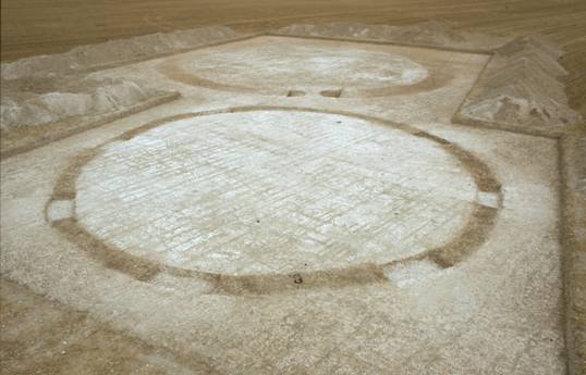
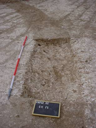
Fig 2 (above) Barrows 1 and 2 partially excavated (2003)
Fig 3 (right) Ditch section of Barrow 1 – partially
excavated.
Ring ditch – Barrow
2
Following
the removal of the overburden of plough soil by machine stripping the
residual
plough soil was trowelled back to reveal a
composite
surface of plough-disturbed natural on the western half of the barrow
with
remnants of an earlier soil on the eastern half of the excavated area.
Approximately
two thirds of the barrow ditch was observable as an arc of soil against
a
largely plough disturbed chalk bedrock.
The soil filled ditch scribes an arc of approximately 22m
diameter with
the width of the ditch being never less than 1.25m.
As the
field was to be brought back into production it was not possible to
proceed
further with the excavation of the barrow that is scheduled to be
completed in
the summer of 2004. However, it is clear
that no funerary deposits remain within the western half of the
interior
surface of the barrow and its close proximity to Barrow 1 suggests that
it will
have suffered a similar degree of erosion.
The ring ditch does have a causeway across it in its
south-western
quadrant which may suggest that it is Later
Neolithic
in origin. The nearest geographical and excavated example of this form
of
monument was investigated by Pitt-Rivers within the Worbarrow
complex near Sixpenny Handley towards the end of the 19th
century
(Barrett et al 1991; Gale
2003a).
Geophysical Surveys at Kings Close
During
the 2002 and 2003 fieldwork campaigns
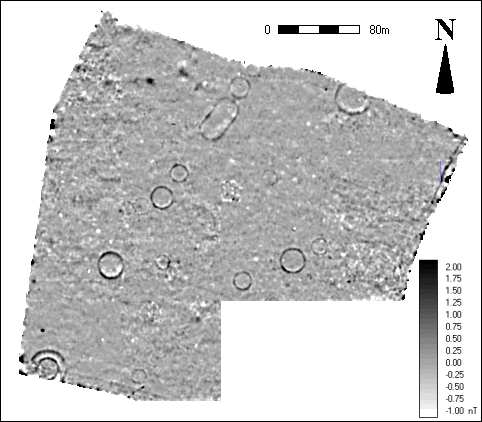
Fig 4 Fluxgate
gradiometer survey of Kings Close 2002-3
© Bournemouth University
Firstly,
there is a length of ditch, showing as a dark (positive) linear anomaly
running
south along inside the eastern boundary of the survey and parallel to
the Wimborne to Cranborne
road. Additional short linear anomalies
that may
represent ditches are to be seen entering the survey area in the south,
running
north-east near the smaller single ring ditch, and one entering from
the
north-west margin of the survey area.
The latter is associated with an area of magnetic noise that
corresponds
to a surface spread of post-mediaeval building material noted during
survey.
Earth resistivity survey revealed the
possible
remains of a building in this area of higher magnetic noise, however,
other
than this, taken across the area as a whole, the earth resistivity
survey provided little additional information. High-resolution
(0.25x0.5m)
caesium gradiometry was undertaken over
the group of
three ring ditches to the south west of the oval ditch. This work
confirmed the
presence of an apparent causeway in the south west quadrant of the
central ring
ditch and provided evidence of ongoing plough damage, suggesting, as
excavation
confirmed, that these feature have been severely truncated in this part
of the
site.
Electromagnetic survey was undertaken over the scheduled double ditch
barrow in the south-west of the survey area, the oval ditch, and the
other
surviving barrow abutting the top north-west edge of the survey area
which is
the bounded by
Geophysical Survey at Great Higher
In
2003 only fluxgate gradiometry was
undertaken in
Great Higher, although further techniques will be incorporated in
future
seasons. The results so far (Fig 5), unlike those from King’s Close,
have
considerably improved on the information currently available from
aerial
photography. Compared to the murky outline of a possible enclosure
identified
on the aerial photographs, the magnetic survey has revealed a complex
palimpsest of ditch systems and enclosures that largely defies
interpretation
and phasing from this initial survey. Along with these linear features
is a
scatter of what are apparently pits (one confirmed as such by
excavation)
spreading across the whole central area of the survey.
These pits presumably continue to both the
east and west, but are not detected in any numbers to the south and
north of
the central area that is defined and bounded by the curvilinear
ditches.
Running north-west to south-east through the survey area is the
tell-tale
positive and negative beaded response of a steel pipeline that has cut
right
through the site, presumably without the presence of the remains being
noted. The discovery of building
foundations during excavation, invisible to gradiometry,
requires that earth resistivity, electromagnetics,
and possibly ground penetrating radar, will be employed during the 2004
season
in an attempt to map these foundations prior to any further excavation.
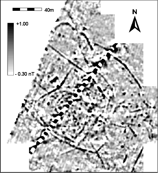
Fig 5 Flugate gradiometer
survey of Great Higher. © Bournemouth University
Trial trenching at Great Higher 2003
As a
result of the initial analysis of the data from the aerial photography
and
geophysical surveys, two trial trenches were instigated during 2003. The larger of the trial trenches (Trench A)
consisted of an ‘L’ shaped trench 50 m long by 2m wide located across
six
boundary/enclosure ditches at the western extent of the field. This trench was thus located to investigate
the nature, extent and possible date of a maximum number of possibly
inter-related boundary ditches, three of which were aligned parallel
with each
other and closely spaced. The plough soil from this trench was hand
excavated
with every fifth barrow of soil screened through a 6mm sieve to sample
any
cultural material contained within it.
As with Kings Close the base of the
plough soil
overlay for the most part natural (plough damaged) chalk bedrock except
in
those areas where the upper fill of six ditches were recovered. The
resultant
ditch sections, with one exception, contained within their secondary
fills
quantities of domestic pottery largely comprising 1st – 3rd
century AD Black burnished wares and likely regional variants of
similar coarse
wares. Occasionally this pottery was
mixed with other domestic debris such as occasional tesserae
and other ceramic materials, as well as oyster shells, all of which
appeared to
be indicative of settlement debris that had fallen into the ditch
rather than
having been thrown in, or otherwise deliberately placed within them. It is likely that the material has washed-in
perhaps after the settlement was abandoned and the land was brought
back into
production at as a yet undefined date.
A
smaller trench (Trench B -8m x 1m) was
located within the centre of the complex of ditches, placed over a
section of
an enclosure ditch which seems to demarcate a ‘D’ shaped enclosure of
approximately 0.4ha and also over what appeared to be one of many ‘pit’
like
features in its interior. This trench was only partially excavated but
an
enclosure ditch was exposed as well as a short length of walling
material
(un-coursed flint rubble) within which were found two bow brooches that
are
possibly 1st –3rd century AD in date. The presence of unexpected in situ
walling material in this trench
necessitates that further geophysical work be undertaken on this site
before
further excavation takes place.
Future work
In
the light of the preliminary findings from two seasons of work
summarised here
plans are now in place to complete the excavation of Barrow 1 in Kings
Close
and to further explore the likely Romano-British settlement complex at
Great
Higher during the summer of 2004.
Acknowledgments
As
this project currently resides in part within the research led teaching
initiative of the archaeological provision at the School of
Conservation Sciences
at Bournemouth University, much thanks is owed to over 60 students
(undergraduate and post-graduate) who have thus far taken part in the
two
seasons of fieldwork. In particular, gratitude is owed to the student
supervisors Phillip Dunn, Martin Blake and Tracey Minall. To our colleagues Dr Ellen Hambleton, Dr Kate Welham,
Dr
Helen Smith, Jeff Chartrand, Damian Evans
and Bronwen Russell, thank you for your
continued help and
support.
Any field project is indebted
to the support of the landowners that its investigations affect, and in
this
instance we are fortunate to have the support and assistance at High
Lea of Sir
Richard Glyn and particularly the estates
manager Mr
John Maidment and his staff.
Contents
- Background
- Field School
- Opportunities to participate 2005
- 2005 Application form
- Summary of field work 2002-3
- Summary of field
work 2004 (forthcoming)
- Excavations at Knowlton southern henge 1994
- Photo gallery (forthcoming)
- Bibliography
This page was
written and compiled by John Gale,
Last revised: Date