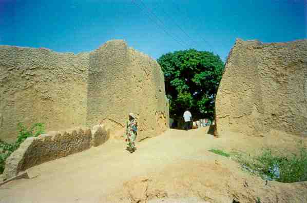
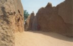
African Legacy - School of Conservation Sciences, Bournemouth University

HAUSALAND WALLED CITIES & TOWNS - remote sensing studies.

Surveying the rich visible archaeology of the sudan savannah

Project: Mapping Africa's Visible Archaeology

Funding:

Aims:
Typical rectilinear town wall, probably C19th.  Note enigmatic linear feature to north-east.
Bifossate rectilinear town wall; and circular enclosure to north.
Karai-Karai: ovoid and circular enclosures - univallate, bifossate and multivallate
Distribution of mapped Karai-Karai enclosures: a process of colonisation several centuries ago, in which middle-belt 'shoulder-carriers' moved north during a humid phase.
Kano's city walls
In 1903, Kano's city walls (above) were regarded as West Africa's most impressive monument. They were 25km long and up to 18m high with narrow fortified gateways. In the mid-C19th, Barth could not get his laden camels through most of the gates; and the above reconstruction has been widened to cater for motor traffic.
Background: Between Lake Chad and the Atlantic Ocean, there are about 10,000 town walls, 25% or more of them on deserted sites. They represent the largest concentration of past urban civilization in black Africa; yet only a handful have been surveyed. There are also about 250,000 unsurveyed tumuli, several million un-charted iron-smelting sites, and an unknown number of ancient terracotta sites, most of which now may have been looted (see main menu for details). Old aerial photographs and other more modern remote-sensing methodologies offer an opportunity to record much of what will otherwise soon be lost altogether.
Click Here Kofar Kabuga
Old gateway in the south-west of Kano city walls, still has its old gate of riveted iron strips which were once mounted on borassus palm doors

 
Kano City walls:

Above - in situ ruins in the early 1990's. The Kano City walls were considered the most impressive monument in West Africa in 1903; but they have become severely eroded today, with borrow-pits for housing encroaching from both sides, and the nouveaux riches building ostentatious houses right across the old wall.  Most gateways have had to be modified to allow modern traffic; but at least one gateway may now be restored authentically with some sections of the wall alongside.


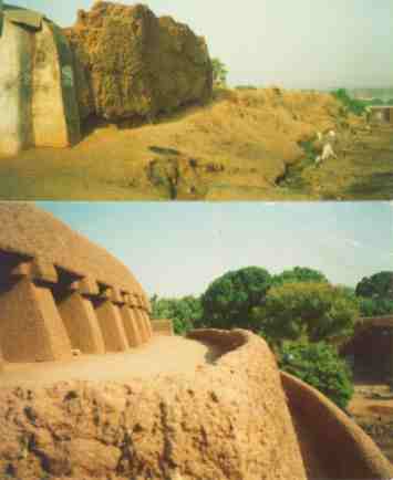
Below:  Reconstruction of the Kano City wall at the Museum of Traditional Nigerian Architecture in Jos, where higher rainfall conditions have meant constant repair work.  The upper parapet was manned by archers and riflemen using loopholes in the wall; whilst cavalry moved rapidly around inside the walls to ensure protection at the weakest spots.  The walls were built entirely of tubali - pear-shaped, sun-dried mud blocks to create a 24 km long, 20m high perimeter.

Kano City Walls
Results: Over 2,500 different past walled sites have been listed in a growing gazeteer. These have been culled from:
Old Ningi
Old Ningi was a nineteenth century cult settlement (ruins above) opposing Kano, Zaria and Bauchi from its hill fortress base using up to 4,000 cavalary. Its mud walls (below) were built on stone-based parapets and presented a complex defence strategy, which the larger kingdoms were unable to breach. It was captured by the British using a local traitor to show a secret way in near the beginning of the C20th.
Goats, supposedly the harbingers of environmental destruction, provide the key to environmental enhancement in the Kano close-settled zone - an extensive, densely populated area in the semi-arid zone of northern Nigeria. Tethered (above) during the rainy season when crops are growing, their dung is gathered to make taki (manure), which is then placed on the fields under permanent cultivation. Over the centuries, more people has resulted in more goats, more taki, better soils, higher crop yields and more trees - the last being mainly gawo (Faidherbia albida), as this ovides browse for the goats when it leafs during the dry season. This is just one of many examples, which qualify many of the negative arguments about the population/environment interface. Kano Goats

 
Survey plans and photographs are being scanned so that they can be related to 16-bit grey scale images of Federal Survey base maps, as well as other cultural and environmental data. African Legacy will supply plan details for educational purposes only: other forms of data dispersal await copyright clearances.

For those wishing to inspect the gazeteer listing, copies can be obtained from:

 
Legacy,
27 Boyle Street, Onikan,
Lagos, Nigeria.
African Legacy
explore@africanlegacy.info


Return to main menu

Return to Cultural landscapes


All data and graphics are copyright to African Legacy  Last Updated December 2001, unless otherwise stated.
Site hosted by School of Conservation Sciences, Bournemouth University